
Tropical Storm Melissa explodes in the Caribbean with spaghetti models showing 'dangerously close' Florida approach
Published: | Updated:
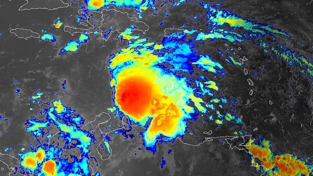
Tropical Storm Melissa has officially become the 11th named storm of the 2025 Atlantic hurricane season.
The National Hurricane Center issued the alert on Tuesday at 11am ET, revealing the system known as Invest 98L has developed a clear center and organized thunderstorms, meaning it has become a tropical storm.
'Satellite imagery shows the system is asymmetric, with the low-level center near the western edge of the central dense overcast,' the NHC said.
'The initial intensity is set at [50mph], based on a blend of the latest satellite intensity estimates, marking the formation of Tropical Storm Melissa.'
An Air Force Hurricane Hunter plane will check the storm this afternoon to get more accurate data on its strength and structure.
Over the next few days, Melissa is expected to slow further and turn north toward a weak spot in the weather pattern. This path would bring it near the southwest tip of Haiti and Jamaica by Thursday.
After that, the NHC alert warned that computer models disagree. Some show Melissa turning northeast, while others predict it could stall or drift west. Most models suggest the storm will stay in the Caribbean through the weekend.
However, some spaghetti models have suggested a dangerously close approach to Florida, with meteorologists warning the US is not out of the clear just yet.
Tropical Storm Melissa formed in the Caribbean Sea on Tuesday morning
Storm Melissa is producing 50mph. Hurricane trackers said it should reach Haiti and Jamaica by Thursday
Florida Storm Chasers posted on X: The latest 00z CMC model run still favors the western track of Tropical Storm Melissa, showing a hurricane 'potentially coming dangerously close to Florida within the next seven days. We'll keep you updated!'
The National Weather Service for Tampa Bay noted that there is no immediate threat to west central and southwest Florida.
However, the agency told residents and visitors to monitor the forecast for updates.
Chris Nabholz, a meteorologist for Deep South Weather, also noted that Melissa will likely not be an issue for the US, but warned 'the Florida Peninsula should keep an eye on it, lots of uncertainty still.'
The NHC released the first official cone for Melissa, showing what meteorologist Gerald Mengel called 'a nightmare.'
'The first official cone for Tropical Storm Melissa shows the nightmare of a forecast this storm will be,' Mengel, who is affiliated with WCCB Charlotte in North Carolina, posted on X.
'All options are still on the table, and it's TOO SOON to rule out US impacts in the 7+ day range.'
The NHC said that Melissa is moving over very warm water, which could help it strengthen.
While most forecast models keep the continental US out of immediate danger, some models suggest a potential direct path toward Florida or a dangerously close approach
The NHC released the first official cone for Melissa, showing what meteorologist Gerald Mengel called 'a nightmare'
However, wind shear and dry air might limit its growth. Because of this, forecasters expect it to strengthen slowly rather than rapidly.
Its future strength will depend on its track, which is still uncertain, the agency explained.
AccuWeather lead hurricane expert Alex DaSilva said in a statement: 'While we think that the chances of a direct U.S. hit from this storm are low right now, it's still on the table should the tropical system make it into the western Caribbean.'
In October, tropical storms entering the western Caribbean typically veer away from Texas and Louisiana.
However, the eastern US, especially Florida, remains at risk for powerful storms.
Matt Devitt, chief meteorologist at Florida's WINK News, said on X: 'The trend has been our friend, with almost all models keeping Melissa east of [Florida].
'I do have a small amount that shows the possibility, but at the present time, it has a better chance of not hitting Florida than hitting Florida.'
AccuWeather also said it is possible the system could become the next hurricane of the season in the warm waters of the central Caribbean.
The Meteorological Service for Jamaica issued a Tropical Storm Watch before the storm was named.
'When the system is in the vicinity of Jamaica, it is expected to produce locally heavy rainfall, strong gusty winds, possibly reaching tropical storm force, primarily over northeastern and southern parishes late Wednesday and Thursday,' the alert stated.
The NHC issued a hurricane watch for the southern coast and the Tiburon peninsula of Haiti.
Florida Storm Chasers posted on X: The latest 00z CMC model run (pictured) still favors the western track of Tropical Storm Melissa, showing a hurricane 'potentially coming dangerously close to Florida within the next seven days'
'Preparations to protect life and property should be completed by Thursday,' the agency warned.
'There is significant uncertainty in the track and intensity forecast of Melissa.'
Although models show uncertainty about the system's path, storm chaser Mitch West warned on X: 'You would be a fool to say this has zero percent chance of impacting the US.
'The chances are low, but it's certainly possible, and we have surely seen it happen in the past. With a large trough signal showing up at the end of the month, you can have weird stuff happen depending on its position.
'A trough doesn't always push things out to sea; it can sometimes pull on things.'
'Folks all through the Antilles from Puerto Rico to Cuba should be prepared for potential impacts from this system if it develops.'
Andy Hazelton, associate Scientist at the University of Miami CIMAS, shared the three scenarios on X over the weekend.
Scenario one shows the storm making a quick northeastern turn across Hispaniola, with a path mostly affecting the Dominican Republic and Haiti.
The second suggests the system stays weak and develops deeper in the Caribbean, moving closer to Nicaragua or Honduras.
The third scenario shows the storm taking longer to form, but developing into a powerful hurricane in the northwest Caribbean.
This track could threaten Cuba, the Bahamas, and potentially extreme South Florida and the Keys.
'I'm personally leaning more towards Scenarios 2 or 3, with slower development and a track either towards Central America or into the NW Caribbean, but certainly Scenario 1 is on the table if it gets organized and feels the weakness to the north,' said Hazelton.
Daily Mail


